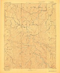
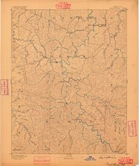
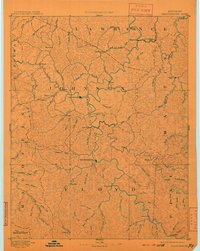
1892 Map of Prestonsburg
USGS Topo · Published 1905About this map
The Big Sandy River and its major tributary, the Levisa Fork of Big Sandy River, dictate the settlement patterns of this eastern Kentucky mountain region during the late nineteenth century. In Floyd and Johnson counties, the primary communities of Prestonsburg and Paintsville are established at vital river bends where local commerce and transit converged. The eastern edge of the map highlights the early industrial infrastructure of the era, specifically the Chattaroi Railway which follows the river to reach Peach Orchard and Richardson.
Find a feature on this map
96 named features on this map. Tap any name to fly to it.
Don’t see what you’re looking for? This feature index may not catch every label — zoom into the map to look around manually.
Map Details
Editions of this 1892 Prestonsburg Map
4 editions found

Other maps of this area

1886 · Prestonsburg
USGS Topo · 1:125,000

1886 · Grundy
USGS Topo · 1:125,000

1887 · Warfield
USGS Topo · 1:125,000

1889 · Salyersville
USGS Topo · 1:125,000

1890 · Whitesburg
USGS Topo · 1:125,000

1890 · Grundy
USGS Topo · 1:125,000

1891 · Hazard
USGS Topo · 1:125,000

1891 · Salyersville
USGS Topo · 1:125,000

1891 · Warfield
USGS Topo · 1:125,000

1892 · Grundy
USGS Topo · 1:125,000