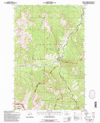
1995 Map of Pretty Prairie
USGS Topo · Published 1997About this map
The Lewis and Clark Range dominates this landscape, where the Bob Marshall Wilderness and Scapegoat Wilderness converge. The topography is defined by the drainage systems of the South Fork Sun River and the West Fork South Fork Sun River, which gather water from numerous named drainages like Wapiti Creek and Nineteen Creek. This mid-1990s record of the high country shows a wilderness almost entirely devoid of permanent structures, yet maintained for travel through the Continental Divide National Scenic Trail. The inclusion of a Game Preserve and specific infrastructure like the Packbridge indicates the area's dual role as a protected wildlife corridor and a destination for backcountry pack-trips. Landmarks such as Deadman Hill and the Sawooth Range serve as significant orientation points within this complex network of ridges and watercourses.
Find a feature on this map
30 named features on this map. Tap any name to fly to it.
Don’t see what you’re looking for? This feature index may not catch every label — zoom into the map to look around manually.
Map Details
Editions of this 1995 Pretty Prairie Map
This is the sole edition of this map. No revisions or reprints were ever made.
Other maps of this area

1902 · Ovando
USGS Topo · 1:125,000

1903 · Saypo
USGS Topo · 1:125,000

1903 · Coopers Lake
USGS Topo · 1:125,000

1905 · Ovando
USGS Topo · 1:125,000

1936 · Silvertip
USGS Topo · 1:96,000

1942 · Silvertip
USGS Topo · 1:125,000

1955 · Choteau
USGS Topo · 1:250,000

1957 · Choteau
USGS Topo · 1:250,000

1958 · Choteau
USGS Topo · 1:250,000

1958 · Glenn Creek
USGS Topo · 1:24,000