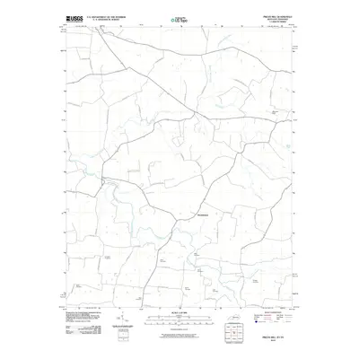
2010 Map of Prices Mill
USGS Topo · Published 2010About this map
The Red River meanders across this rural landscape straddling the Kentucky and Tennessee border, its course flanked by a dense network of country roads and family cemeteries. Near the center of the sheet, the settlement of Providence serves as a local crossroads, surrounded by agricultural lands and drainages like Sulphur Spring Creek and Neely Branch. The map reveals a high concentration of small family burial grounds, including the Campbell, Babb, Rose, and Doss sites, which suggest a long-established pattern of generational farm ownership. This network of namesake roads, such as Upper Prices Mill Rd and Russellville-Gallatin Rd, indicates the area's historical reliance on mill sites and regional transit routes connecting to larger market towns in the early 21st century.
Find a feature on this map
55 named features on this map. Tap any name to fly to it.
Don’t see what you’re looking for? This feature index may not catch every label — zoom into the map to look around manually.
Map Details
Editions of this 2010 Prices Mill Map
This is the sole edition of this map. No revisions or reprints were ever made.
Other maps of this area

1942 · Gallatin
USGS Topo · 1:100,000

1951 · Adairville
USGS Topo · 1:24,000

1951 · Woodburn
USGS Topo · 1:24,000

1951 · Franklin
USGS Topo · 1:24,000

1951 · Prices Mill
USGS Topo · 1:24,000

1951 · Auburn
USGS Topo · 1:24,000

1952 · Youngville
USGS Topo · 1:24,000

1952 · Dennis
USGS Topo · 1:24,000

1953 · Orlinda
USGS Topo · 1:24,000
1956 · Portland
USGS Topo · 1:24,000