
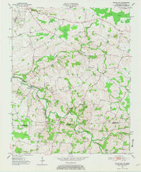
1951 Map of Prices Mill
USGS Topo · Published 1952About this map
The winding Red River carves through this agricultural borderland, defining the transition between Simpson County, Kentucky, and Robertson County, Tennessee. Near a prominent bend in the water, the settlement of Prices Mill serves as a local focal point, supported by nearby rural institutions like the Red River Sch and White Hill Ch. The landscape is a network of small drainage systems such as Sulphur Spring Creek and Summers Branch, interspersed with pockets of low-lying terrain like Robey Swamp. Small crossroads communities and family-named locations such as Middleton, Neosheo, and Schweizer are connected by a web of light-duty roads, reflecting a mid-century period of quiet rural persistence. This survey provides a precise look at the placement of country churches like Milliken Chapel and Bethany Ch, which anchored the social life of these dispersed farming families.
Find a feature on this map
18 named features on this map. Tap any name to fly to it.
Don’t see what you’re looking for? This feature index may not catch every label — zoom into the map to look around manually.
Map Details
Editions of this 1951 Prices Mill Map
2 editions found
Other maps of this area

1942 · Gallatin
USGS Topo · 1:100,000

1951 · Adairville
USGS Topo · 1:24,000

1951 · Woodburn
USGS Topo · 1:24,000

1951 · Franklin
USGS Topo · 1:24,000

1951 · Auburn
USGS Topo · 1:24,000

1952 · Youngville
USGS Topo · 1:24,000

1952 · Dennis
USGS Topo · 1:24,000

1953 · Orlinda
USGS Topo · 1:24,000
1956 · Portland
USGS Topo · 1:24,000

1956 · Nashville
USGS Topo · 1:250,000