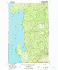
1967 Map of Priest Lake SE
USGS Topo · Published 1993About this map
Kaniksu National Forest defines the eastern shoreline of Priest Lake in this late 1960s survey. The map details the transition between the deep waters of the lake and the steep ascent of Horton Ridge. This eastern bank is characterized by a series of distinct inlets and points, including Indian Creek Bay and the more developed Cavanaugh Bay, which serves as a recreational and logistical hub with the Cavanaugh Bay Airport and nearby Sherwood Beach. The interior landscape is marked by numerous watercourses such as Hunt Creek and Soldier Creek that cut through the terrain toward the high elevations of Camels Prairie. For those studying the evolution of Idaho's wilderness access, the network of 4wd tracks and the East Shore Road illustrate the early infrastructure supporting the Indian Creek Campground and the timber-rich highlands of Bonner County.
Find a feature on this map
30 named features on this map. Tap any name to fly to it.
Don’t see what you’re looking for? This feature index may not catch every label — zoom into the map to look around manually.
Map Details
Editions of this 1967 Priest Lake SE Map
3 editions found
Other maps of this area

1901 · Sandpoint
USGS Topo · 1:125,000

1911 · Priest Lake
USGS Topo · 1:250,000

1911 · Sandpoint
USGS Topo · 1:125,000

1913 · Priest Lake
USGS Topo · 1:250,000

1958 · Sandpoint
USGS Topo · 1:250,000

1963 · Sandpoint
USGS Topo · 1:250,000

1967 · Priest Lake SE
USGS Topo · 1:24,000

1967 · Coolin
USGS Topo · 1:24,000

1967 · Priest Lake NE
USGS Topo · 1:24,000

1967 · Priest Lake NW
USGS Topo · 1:24,000