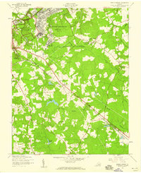
1952 Map of Prince George
USGS Topo · Published 1959About this map
Prince George and the surrounding Virginia countryside appear in 1952 as a landscape defined by military installations and deep-rooted rural communities. The U S Military Reservation and Fort Lee dominate the northern terrain, contrasted by the civil history preserved within the Petersburg Natl Military Park, where historical Breastworks are still noted. The Norfolk and Western railroad cuts a straight line through the center of the sheet, passing through the settlement of New Bohemia. Local life is anchored by numerous country churches, including Sacred Heart Ch, Pleasant Grove Ch, and Bethlehem Ch. The geography is heavily influenced by slow-moving water and wetlands, notably Blackwater Swamp and Second Swamp, which are punctuated by family-named landmarks such as Hanzlins Pond, Jandls Pond, and Bakers Pond.
Find a feature on this map
37 named features on this map. Tap any name to fly to it.
Don’t see what you’re looking for? This feature index may not catch every label — zoom into the map to look around manually.
Map Details
Editions of this 1952 Prince George Map
2 editions found
Other maps of this area

1894 · Bermuda Hundred
USGS Topo · 1:62,500

1894 · Petersburg
USGS Topo · 1:62,500

1918 · Charles City
USGS Topo · 1:62,500

1919 · Disputanta
USGS Topo · 1:62,500

1943 · Hopewell
USGS Topo · 1:31,680

1943 · Disputanta
USGS Topo · 1:31,680

1943 · Richmond
USGS Topo · 1:250,000

1944 · Reams
USGS Topo · 1:31,680
1944 · Chester
USGS Topo · 1:31,680
1944 · Petersburg
USGS Topo · 1:31,680