1958 Map of Prince Rupert C-2 and C-3
USGS Topo · Published 1960About this map
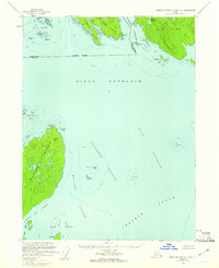
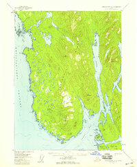
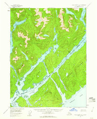
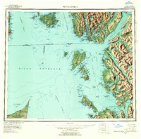
The maritime border between the United States and Canada bisects this late-1950s survey of the Alexander Archipelago. Dixon Entrance dominates the central waters, serving as the gateway to a complex network of channels and sounds including Main Passage and Chatham Sound. On the northern side, Wales Island and its sheltered Wales Harbour sit adjacent to Sitklan Island, where Klan Hill and identified Ruins suggest a history of habitation near the international boundary. South across the Oriflamme Passage, the significant landmass of Dundas Island rises to Table Hill. This sheet represents a collaborative cartographic effort, synthesizing Alaskan aerial photogrammetry with Canadian survey data to map the treacherous reefs and islands of the inner passage, from the Lord Islands in the west to the cluster of Gnarled Is and Connis Rks.
Find a feature on this map
43 named features on this map. Tap any name to fly to it.
Don’t see what you’re looking for? This feature index may not catch every label — zoom into the map to look around manually.
Map Details
Editions of this 1958 Prince Rupert C-2 and C-3 Map
2 editions found

Other maps of this area

1951 · Prince Rupert
USGS Topo · 1:250,000
1955 · Prince Rupert D-3
USGS Topo · 1:63,360
1955 · Prince Rupert D-2
USGS Topo · 1:63,360
1959 · Prince Rupert
USGS Topo · 1:250,000

1964 · Prince Rupert
USGS Topo · 1:250,000

2018 · Prince Rupert C-2 NW
USGS Topo · 1:25,000

2018 · Prince Rupert D-2 SE
USGS Topo · 1:25,000

2018 · Prince Rupert D-3 SW
USGS Topo · 1:25,000

2018 · Prince Rupert C-3 NE
USGS Topo · 1:25,000

2018 · Prince Rupert D-3 SE
USGS Topo · 1:25,000