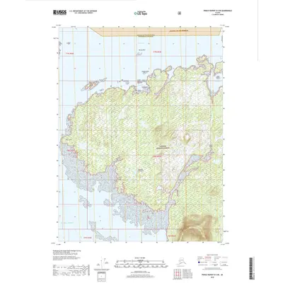
2018 Map of Prince Rupert D-5 NE
USGS Topo · Published 2018About this map
Duke Island dominates this portion of the Alexander Archipelago, illustrating the intricate coastline and dense maritime geography of Southeast Alaska. Part of the Tongass National Forest, the landscape is defined by its maze of inlets and small islands, including Goose Tongue Island, Ray Island, and the Vegas Islands. To the north, the boundary of the Annette Island Reserve cuts through Felice Strait, where the treacherous Tamgas Reef sits as a significant hazard for local navigation. The topography is notably punctuated by Mt Lazaro in the southeast, while the western shore is marked by the prominent Point White. This detailed survey of the Unorganized Borough captures the remote interface of island terrain and the Pacific Ocean, offering clear documentation of coastal landmarks like Ryus Bay and Dog Bay that are vital to maritime navigation in these waters.
Find a feature on this map
29 named features on this map. Tap any name to fly to it.
Don’t see what you’re looking for? This feature index may not catch every label — zoom into the map to look around manually.
Map Details
Editions of this 2018 Prince Rupert D-5 NE Map
This is the sole edition of this map. No revisions or reprints were ever made.
Other maps of this area

1951 · Prince Rupert
USGS Topo · 1:250,000

1952 · Ketchikan
USGS Topo · 1:250,000

1955 · Ketchikan A-4
USGS Topo · 1:63,360

1955 · Ketchikan A-5
USGS Topo · 1:63,360
1955 · Prince Rupert D-5
USGS Topo · 1:63,360
1955 · Prince Rupert D-4
USGS Topo · 1:63,360

1955 · Ketchikan
USGS Topo · 1:250,000

1959 · Prince Rupert
USGS Topo · 1:250,000

1964 · Prince Rupert
USGS Topo · 1:250,000
2017 · Ketchikan A-5 SE
USGS Topo · 1:25,000