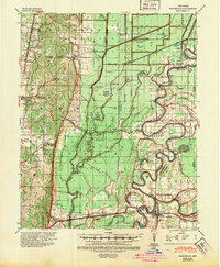
1940 Map of Princedale
USGS Topo · Published 1947About this map
The St Francis River dictates the landscape of this delta region, winding through a complex system of bars and sloughs where Poinsett, Cross, and Crittenden counties meet. This 1940 edition reflects an era of intense hydrological management, evidenced by the expansive Steep Gut Floodway and a dense network of numbered drainage ditches like Ditch No 10. The St Louis Southwestern and Missouri Pacific railroads anchor the local economy, connecting settlements such as Cherry Valley and Parkin. Rural life is marked by numerous country schools and churches, including the Pleasant Hill School and Mt Olive Ch. Unique river features like Twist Ferry and the Lumber Yard near Turney illustrate the water-based industry and transit of the pre-war period. The map also captures several family-named landmarks such as the Yarbo Place and Love Place, providing significant value for genealogists studying this corner of Arkansas.
Find a feature on this map
75 named features on this map. Tap any name to fly to it.
Don’t see what you’re looking for? This feature index may not catch every label — zoom into the map to look around manually.
Map Details
Editions of this 1940 Princedale Map
2 editions found
Other maps of this area

1939 · Vanndale
USGS Topo · 1:62,500

1939 · Weiner
USGS Topo · 1:62,500

1939 · Wynne
USGS Topo · 1:62,500

1939 · Edmondson
USGS Topo · 1:62,500

1940 · Deckerville
USGS Topo · 1:62,500

1940 · Princedale
USGS Topo · 1:62,500

1940 · Whitmore
USGS Topo · 1:62,500

1940 · Dee
USGS Topo · 1:62,500

1941 · Marked Tree
USGS Topo · 1:62,500

1953 · Memphis
USGS Topo · 1:250,000