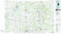
1986 Map of Princeton
USGS Topo · Published 1986About this map
The Wabash River and White River converge in this mid-1980s landscape, defining the watery border between southwestern Indiana and Illinois. The city of Princeton serves as a central hub, surrounded by agricultural townships and the growing industrial presence of Evansville to the south. Transportation networks are a primary focus, featuring the intersection of Interstate 64 and U.S. 41, alongside the tracks of the Southern and Conrail railroads. This era shows a region balanced between its river-valley roots and modern infrastructure, visible in the sprawling Patoka State Fish and Wildlife Area and various strip mines located throughout Pike Co and Warrick Co. Smaller settlements like Fort Branch, Haubstadt, and the riverside New Harmony appear alongside extensive drainage systems such as Scott Ditch and Greeley Ditch, which have long managed the fertile bottomlands.
Find a feature on this map
216 named features on this map. Tap any name to fly to it.
Don’t see what you’re looking for? This feature index may not catch every label — zoom into the map to look around manually.
Map Details
Editions of this 1986 Princeton Map
2 editions found
Other maps of this area

1900 · St Meinrad
USGS Topo · 1:62,500

1900 · De Gonia Springs
USGS Topo · 1:62,500

1901 · Owensboro
USGS Topo · 1:62,500

1901 · Princeton
USGS Topo · 1:62,500

1901 · Haubstadt
USGS Topo · 1:62,500

1902 · Ditney
USGS Topo · 1:125,000

1902 · Degonia Springs
USGS Topo · 1:62,500

1902 · Boonville
USGS Topo · 1:62,500

1903 · St. Meinrad
USGS Topo · 1:62,500

1903 · Velpen
USGS Topo · 1:62,500