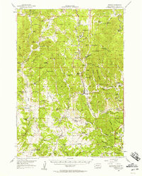
1956 Map of Pringle
USGS Topo · Published 1958About this map
Pringle and the surrounding ranchlands of Custer County are depicted during a period of active resource extraction and institutional presence within the Black Hills National Forest. The landscape is a dense network of mining operations, including the Tin Mountain Mine, Rainbow No 4 Mine, and White Elephant Mine, alongside the significant State Sanatorium located at Sanator. This era shows a community structured around both the Burlington and Chicago railroad line and a distributed system of rural education, evidenced by facilities like the Mayo Sch and the Pleasant Valley Sch (Abandoned).
Find a feature on this map
131 named features on this map. Tap any name to fly to it.
Don’t see what you’re looking for? This feature index may not catch every label — zoom into the map to look around manually.
Map Details
Editions of this 1956 Pringle Map
This is the sole edition of this map. No revisions or reprints were ever made.
Other maps of this area

1894 · Hermosa
USGS Topo · 1:125,000

1896 · Oelrichs
USGS Topo · 1:125,000

1896 · Harney Peak
USGS Topo · 1:125,000

1900 · Oelrichs
USGS Topo · 1:125,000

1901 · Hermosa
USGS Topo · 1:125,000

1901 · Harney Peak
USGS Topo · 1:125,000

1902 · Edgemont
USGS Topo · 1:125,000

1950 · Hot Springs
USGS Topo · 1:24,000

1950 · Edgemont NE
USGS Topo · 1:24,000

1950 · Minnekahta
USGS Topo · 1:24,000