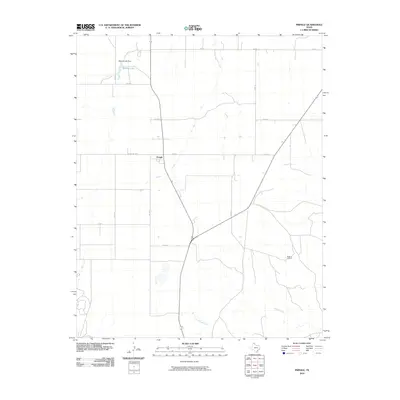
2010 Map of Pringle
USGS Topo · Published 2010About this map
Pringle serves as the central focal point of this Panhandle landscape, situated at the intersection of several regional routes in Hutchinson County. The terrain is defined by a series of intermittent watercourses including Big Creek, Cottonwood Creek, and Bugby Creek, which drain the open ranching country. North of the primary settlement, Roberts Lake and the associated Roberts Lake Dam provide a notable hydrological feature amidst the grid of section roads like Co RD 9 and Co RD 13. The mapping of the Rocking D Ranch in the southeast quadrant reflects the large-scale landholdings that characterize this part of the Texas high plains. This survey captures the infrastructure of the local petroleum or ranching economy through its network of numbered county roads and state-maintained routes like Ranch Rd 1598.
Find a feature on this map
18 named features on this map. Tap any name to fly to it.
Don’t see what you’re looking for? This feature index may not catch every label — zoom into the map to look around manually.
Map Details
Editions of this 2010 Pringle Map
This is the sole edition of this map. No revisions or reprints were ever made.
Other maps of this area

1953 · Plemons
USGS Topo · 1:24,000

1953 · Stinnett
USGS Topo · 1:24,000

1953 · Stinnett Station
USGS Topo · 1:24,000

1953 · Pringle
USGS Topo · 1:24,000

1954 · Perryton
USGS Topo · 1:250,000

1954 · Amarillo
USGS Topo · 1:250,000

1958 · Perryton
USGS Topo · 1:250,000

1958 · Amarillo
USGS Topo · 1:250,000

1974 · Morse
USGS Topo · 1:24,000
1974 · Camp Creek
USGS Topo · 1:24,000