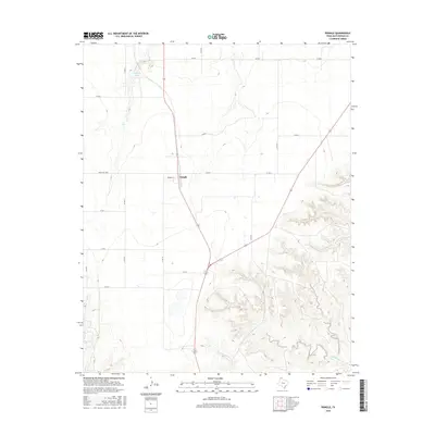
2016 Map of Pringle
USGS Topo · Published 2016About this map
Pringle stands as a focal point in this 2016 survey of the Texas Panhandle, positioned where the High Plains transition into the broken drainage basins of the Canadian River valley. The community is defined by its grid of local streets, including Womble St, and its connection to the regional road network via Ranch Rd 1598. To the north, the terrain is marked by Roberts Lake, while the southern and eastern portions of the map reveal a more intricate landscape of draws and seasonal watercourses. The erosional patterns of Cottonwood Cr and Bugby Creek (also labeled as Bugby Cr) create a distinct contrast with the flatter agricultural and ranching sections to the west. This geography illustrates the intersection of steady upland prairie and the rugged, winding creek beds typical of Hutchinson County.
Find a feature on this map
17 named features on this map. Tap any name to fly to it.
Don’t see what you’re looking for? This feature index may not catch every label — zoom into the map to look around manually.
Map Details
Editions of this 2016 Pringle Map
This is the sole edition of this map. No revisions or reprints were ever made.
Other maps of this area

1953 · Plemons
USGS Topo · 1:24,000

1953 · Stinnett
USGS Topo · 1:24,000

1953 · Stinnett Station
USGS Topo · 1:24,000

1953 · Pringle
USGS Topo · 1:24,000

1954 · Perryton
USGS Topo · 1:250,000

1954 · Amarillo
USGS Topo · 1:250,000

1958 · Perryton
USGS Topo · 1:250,000

1958 · Amarillo
USGS Topo · 1:250,000

1974 · Morse
USGS Topo · 1:24,000
1974 · Camp Creek
USGS Topo · 1:24,000