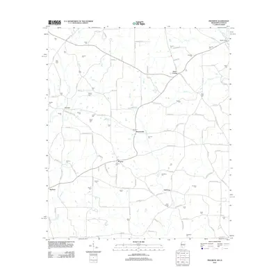
2012 Map of Progress
USGS Topo · Published 2012About this map
Bogue Chitto and Silver Cr frame a landscape defined by generational family lands along the Mississippi-Louisiana border. Small settlements like Progress, Smithburg, and Simmonsville serve as anchors for a rural network of roads including Old 24 Ext and Old River Rd. The area is particularly rich in family-named burial grounds, such as the Kendrick-Pounds Cem and Brewer-Webb Cem, which reflect the deep genealogical roots of Pike County. These sites are often found near creek junctions or tucked away on roads like Fortenberry Rd. The terrain is characterized by the watershed of the Bala Chitto Cr, with crossroads like Dykes Crossing and Gladhurst marking the historical transition points between agricultural tracts.
Find a feature on this map
111 named features on this map. Tap any name to fly to it.
Don’t see what you’re looking for? This feature index may not catch every label — zoom into the map to look around manually.
Map Details
Editions of this 2012 Progress Map
This is the sole edition of this map. No revisions or reprints were ever made.
Other maps of this area

1939 · Sunny Hill
USGS Topo · 1:31,680

1939 · Clifton
USGS Topo · 1:31,680

1940 · Spring Creek
USGS Topo · 1:31,680

1953 · Natchez
USGS Topo · 1:250,000

1954 · Baton Rouge
USGS Topo · 1:250,000

1956 · Natchez
USGS Topo · 1:250,000

1956 · Baton Rouge
USGS Topo · 1:250,000
1958 · Mount Hermon
USGS Topo · 1:62,500
1958 · Franklinton
USGS Topo · 1:62,500

1959 · Natchez
USGS Topo · 1:250,000