
1968 Map of Promontory Point
USGS Topo · Published 1970About this map
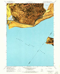
Great Salt Lake dominates this 1960s perspective of the terminal point of the Promontory Mountains, where the industrial infrastructure of the Southern Pacific railroad meets the water. The engineering marvel of the Lucin Cutoff traverses the southern edge of the peninsula, supported by a network of specialized facilities including a Pumping Station, Gaging Sta, and a substantial Elevated Flume near Saline. This map details the intersection of transportation and natural resource extraction, as evidenced by several Salt Evaporators and an expansive Mud Flat that separates the rising peaks from the shoreline. Further south across the water, the northern tip of Fremont Island is visible, while local activity is noted by a Landing Strip and a Jeep Trail winding through the uplands. The landscape is a stark mix of high-altitude Prospects and sea-level industrial outposts at the historic Promontory Point.
Find a feature on this map
23 named features on this map. Tap any name to fly to it.
Don’t see what you’re looking for? This feature index may not catch every label — zoom into the map to look around manually.
Map Details
Editions of this 1968 Promontory Point Map
2 editions found
Other maps of this area

1954 · Brigham City
USGS Topo · 1:250,000

1955 · Willard Spur
USGS Topo · 1:24,000

1955 · Fremont Island
USGS Topo · 1:24,000

1958 · Brigham City
USGS Topo · 1:250,000

1962 · Brigham City
USGS Topo · 1:250,000

1968 · Indian Cove
USGS Topo · 1:24,000

1968 · Pokes Point
USGS Topo · 1:24,000

1968 · Fremont Island SW
USGS Topo · 1:24,000

1968 · Carrington Island
USGS Topo · 1:24,000
1969 · Carrington Island NE
USGS Topo · 1:24,000