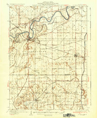
1936 Map of Prophetstown
USGS Topo · Published 1936About this map
The Rock River dominates the northern landscape of this 1930s survey, winding past Lyndon and Prophetstown while creating complex water systems like Quincy Slough and Hamilton Slough. The region's agricultural and social fabric is clearly defined by a dense network of country schools such as Hooppole Grove Sch and Highland Sch, alongside numerous community hubs like Tampico and Hooppole.
Find a feature on this map
88 named features on this map. Tap any name to fly to it.
Don’t see what you’re looking for? This feature index may not catch every label — zoom into the map to look around manually.
Map Details
Editions of this 1936 Prophetstown Map
3 editions found

Other maps of this area

1891 · Clinton
USGS Topo · 1:62,500

1894 · Clinton
USGS Topo · 1:62,500

1899 · Clinton
USGS Topo · 1:125,000

1921 · Buda
USGS Topo · 1:62,500

1923 · Buda
USGS Topo · 1:62,500

1929 · Annawan
USGS Topo · 1:62,500

1930 · Woodsung
USGS Topo · 1:48,000

1932 · Prophetstown
USGS Topo · 1:48,000

1932 · Annawan
USGS Topo · 1:62,500

1934 · Geneseo
USGS Topo · 1:62,500