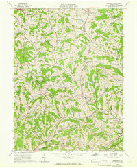
1964 Map of Prosperity
USGS Topo · Published 1966About this map
Tenmile Creek and its many winding tributaries define the rugged landscape of southern Washington County in the mid-1960s. This survey focuses on the crossroads of Prosperity, where the local landscape is dotted with small-scale rural infrastructure like the Prosperity Township Sch and the nearby Covered Bridge. The area is characterized by a high density of local history markers, including several family and community burial grounds such as South Buffalo Cem, Elliott Cem, and Carroll Cem.
Find a feature on this map
35 named features on this map. Tap any name to fly to it.
Don’t see what you’re looking for? This feature index may not catch every label — zoom into the map to look around manually.
Map Details
Editions of this 1964 Prosperity Map
Other maps of this area

1901 · Amity
USGS Topo · 1:62,500

1901 · Waynesburg
USGS Topo · 1:62,500

1904 · Amity
USGS Topo · 1:62,500

1904 · Waynesburg
USGS Topo · 1:62,500

1905 · Rogersville
USGS Topo · 1:62,500

1907 · Claysville
USGS Topo · 1:62,500

1949 · Clarksburg
USGS Topo · 1:250,000

1951 · Canton
USGS Topo · 1:250,000

1953 · Canton
USGS Topo · 1:250,000
1953 · Washington East
USGS Topo · 1:24,000