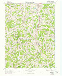
1964 Map of Prosperity
USGS Topo · Published 1973About this map
Prosperity and the surrounding townships of Morris and South Franklin reflect a mid-century Pennsylvania landscape where agricultural tradition met industrial energy development. Numerous oil and gas wells dot the hillsides, a quiet indication of the subsurface resource extraction that shaped the local economy. The network of winding roads connects rural clusters such as Lagonda, Van Buren, and Dunns Station, which is situated along the Penn Central rail line in the southeast corner.
Find a feature on this map
44 named features on this map. Tap any name to fly to it.
Don’t see what you’re looking for? This feature index may not catch every label — zoom into the map to look around manually.
Map Details
Editions of this 1964 Prosperity Map
Other maps of this area

1901 · Amity
USGS Topo · 1:62,500

1901 · Waynesburg
USGS Topo · 1:62,500

1904 · Amity
USGS Topo · 1:62,500

1904 · Waynesburg
USGS Topo · 1:62,500

1905 · Rogersville
USGS Topo · 1:62,500

1907 · Claysville
USGS Topo · 1:62,500

1949 · Clarksburg
USGS Topo · 1:250,000

1951 · Canton
USGS Topo · 1:250,000

1953 · Canton
USGS Topo · 1:250,000
1953 · Washington East
USGS Topo · 1:24,000