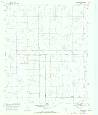
1969 Map of Providence
USGS Topo · Published 1971About this map
Providence and the surrounding agricultural landscape define this 1969 survey of the High Plains, where the borders of Swisher, Hale, and Floyd counties converge. The terrain is marked by numerous ephemeral water features and depressional basins, notably Rock Draw, alongside an extensive network of irrigation wells. Industrial activity is centered on the cotton economy, as evidenced by the Providence Gin and Crume Gin located in the southern portion of the quadrangle. A small settlement at Barrett and a remote Landing Strip illustrate the area's specialized transportation and infrastructure needs during this era of late-century farming development. This map provides a detailed record of the West Texas landscape before extensive modernization, capturing the exact placement of rural landmarks and the precise county lines that shaped local governance and land ownership.
Find a feature on this map
16 named features on this map. Tap any name to fly to it.
Don’t see what you’re looking for? This feature index may not catch every label — zoom into the map to look around manually.
Map Details
Editions of this 1969 Providence Map
This is the sole edition of this map. No revisions or reprints were ever made.
Other maps of this area

1954 · Plainview
USGS Topo · 1:250,000

1958 · Plainview
USGS Topo · 1:250,000

1965 · Rock Creek
USGS Topo · 1:24,000

1965 · Silverton SW
USGS Topo · 1:24,000

1965 · Plainview
USGS Topo · 1:24,000

1966 · Sterley
USGS Topo · 1:24,000

1968 · Aiken
USGS Topo · 1:24,000

1969 · Kress East
USGS Topo · 1:24,000

1969 · Claytonville
USGS Topo · 1:24,000

1969 · Claytonville NW
USGS Topo · 1:24,000