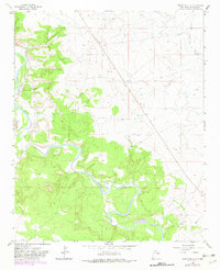
1963 Map of Puerto De Luna
USGS Topo · Published 1982About this map
The Pecos River carves a deep, winding valley through this part of Guadalupe County, sustaining the community of Puerto de Luna. The landscape is defined by the vital irrigation systems that hug the riverbanks, specifically the West Puerto de Luna Ditch and the East Puerto de Luna Ditch. These man-made features are essential markers of the agricultural heritage and settlement patterns in this arid region, where water access dictated the placement of homes and fields. Genealogy researchers will find the Nuestra Senora de Refugio Cem centrally located near the town, providing a specific point of interest for local family histories. Beyond the central valley, the terrain transitions to ranching country, with family-named operations like Willis Ranch and Z R Ranch located near the Arroyo San Juan de Dios, showing the distribution of land use in the early 1960s.
Find a feature on this map
8 named features on this map. Tap any name to fly to it.
Don’t see what you’re looking for? This feature index may not catch every label — zoom into the map to look around manually.
Map Details
Editions of this 1963 Puerto De Luna Map
2 editions found
Other maps of this area

1954 · Fort Sumner
USGS Topo · 1:250,000

1958 · Fort Sumner
USGS Topo · 1:250,000

1963 · Santa Rosa
USGS Topo · 1:24,000

1963 · Puerto Creek
USGS Topo · 1:24,000

1963 · Sunshine Mesa
USGS Topo · 1:24,000

1963 · Puerto De Luna
USGS Topo · 1:24,000

1964 · Fallon Ranch
USGS Topo · 1:24,000
1964 · Harben Lake
USGS Topo · 1:24,000

1966 · Gibbons Ranch
USGS Topo · 1:24,000

1966 · Ojo Negro Creek
USGS Topo · 1:24,000