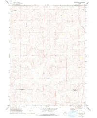
1972 Map of Pullen Ranch
USGS Topo · Published 1993About this map
The high plains of Nebraska's Sandhills region are defined by a network of private homesteads and cattle operations in this early 1970s survey. Named properties including The Old Homestead Ranch and the eponymous Pullen Ranch are scattered across a landscape of undulating dunes and dry basins. The map illustrates a rural western economy centered on ranching, where small settlements like Connell Ranch and Hoban Ranch serve as the primary landmarks in an otherwise open expanse. Running east-to-west across the lower third of the sheet, the county line between McPherson Co and Lincoln Co marks a administrative boundary through the grazing lands. This document is a precise record of the land use and property divisions before modern shifts in regional agriculture.
Find a feature on this map
6 named features on this map. Tap any name to fly to it.
Don’t see what you’re looking for? This feature index may not catch every label — zoom into the map to look around manually.
Map Details
Editions of this 1972 Pullen Ranch Map
2 editions found
Other maps of this area

1898 · Paxton
USGS Topo · 1:125,000

1899 · North Platte
USGS Topo · 1:125,000

1901 · Paxton
USGS Topo · 1:125,000

1902 · North Platte
USGS Topo · 1:125,000

1949 · Wright Valley
USGS Topo · 1:62,500

1951 · Tryon
USGS Topo · 1:62,500

1951 · Wright Valley
USGS Topo · 1:62,500

1954 · North Platte
USGS Topo · 1:250,000

1956 · North Platte
USGS Topo · 1:250,000

1957 · North Platte
USGS Topo · 1:250,000