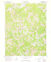
1964 Map of Pullman
USGS Topo · Published 1977About this map
The town of Pullman and the surrounding Ritchie County landscape are defined by the winding tributaries of the Hughes River, including the North Fork and South Fork. In this mid-century period, the area exhibits a transition from traditional rural life to industrial activity, evidenced by the numerous oil and gas wells dotting the hills alongside historic landmarks like Mt Pisgah and King Knob. The settlement pattern follows the valley floors, with the community of Berea and scattered churches such as Beason Ch and My Zion Ch serving the local population. Infrastructure for the energy sector is prominent, with several pipelines, a Pumping Station, and a Compressor Station supporting the extraction of natural resources throughout the Union and Clay districts.
Find a feature on this map
59 named features on this map. Tap any name to fly to it.
Don’t see what you’re looking for? This feature index may not catch every label — zoom into the map to look around manually.
Map Details
Editions of this 1964 Pullman Map
2 editions found
Other maps of this area

1905 · West Union
USGS Topo · 1:62,500

1906 · Saint Marys
USGS Topo · 1:62,500

1906 · Holbrook
USGS Topo · 1:62,500

1907 · Harrisville
USGS Topo · 1:62,500

1924 · St Marys
USGS Topo · 1:62,500

1924 · Harrisville
USGS Topo · 1:62,500

1924 · West Union
USGS Topo · 1:62,500

1924 · Holbrook
USGS Topo · 1:62,500

1926 · Harrisville
USGS Topo · 1:62,500

1926 · Holbrook
USGS Topo · 1:62,500