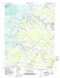
1968 Map of Pungoteague
USGS Topo · Published 1992About this map
Pungoteague Creek and Onancock Creek carve deep into the Virginia shoreline on this 1968 topographic-bathymetric survey, reflecting the maritime identity of the Eastern Shore. The landscape is defined by its series of distinct necks, including Broadway Neck, Yeo Neck, and Hacks Neck, which create a complex network of marshes and protected waterways. Small settlements and community anchors like Crockett Town, Savageville, and Pungoteague dot the interior, while the shoreline is marked by commercial and recreational landmarks such as Boggs Wharf and the Eastern Shore Yacht and Country Club. Further inland, the Accomack County Airport and the South Accomack Sch indicate the mid-century development of the region's infrastructure. The detailed bathymetric data illustrates the shifting shoals of the Chesapeake Bay, including Scarborough Island and Finneys Island, which have historically shaped local navigation and fishing.
Find a feature on this map
84 named features on this map. Tap any name to fly to it.
Don’t see what you’re looking for? This feature index may not catch every label — zoom into the map to look around manually.
Map Details
Editions of this 1968 Pungoteague Map
3 editions found
Other maps of this area

1903 · Crisfield
USGS Topo · 1:62,500

1920 · Crisfield
USGS Topo · 1:62,500

1931 · Accomac
USGS Topo · 1:48,000

1935 · Accomac
USGS Topo · 1:62,500

1942 · Chesconessex
USGS Topo · 1:31,680

1942 · Nandua Creek
USGS Topo · 1:24,000

1942 · Tangier Island
USGS Topo · 1:24,000

1942 · Parksley
USGS Topo · 1:24,000

1943 · Jamesville
USGS Topo · 1:31,680

1943 · Pungoteague
USGS Topo · 1:31,680