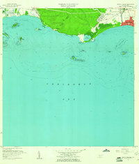
1958 Map of Punta Cucharas
USGS Topo · Published 1961About this map
Playa de Ponce stands as a bustling coastal hub on the southern shore of Puerto Rico during the late 1950s. The landscape transitions from the urban density of Canas Urbano and the neighborhood of Los Pámpanos to the managed agriculture of Hacienda Matilde. Infrastructure is well-defined by the Ferrocarril de Puerto Rico and the historic Antigua Via, while the shoreline is punctuated by local educational landmarks like the Escuela Segunda Unidad de Encarnación.
Find a feature on this map
36 named features on this map. Tap any name to fly to it.
Don’t see what you’re looking for? This feature index may not catch every label — zoom into the map to look around manually.
Map Details
Editions of this 1958 Punta Cucharas Map
2 editions found
Other maps of this area

1945 · Playa De Ponce
USGS Topo · 1:30,000

1945 · Ponce
USGS Topo · 1:30,000

1946 · Punta Cuchara
USGS Topo · 1:30,000

1946 · Yauco
USGS Topo · 1:30,000

1946 · Punta Verraco
USGS Topo · 1:30,000

1946 · Penuelas
USGS Topo · 1:30,000

1947 · Punta Gughara NE
USGS Topo · 1:10,000
1947 · Yauco SE
USGS Topo · 1:10,000

1947 · Ponce SO
USGS Topo · 1:10,000
1947 · Punta Verraco NE
USGS Topo · 1:10,000