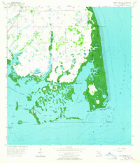
1957 Map of Punta Gorda SW
USGS Topo · Published 1964About this map
Mound Key, Indian Mound, and Cash Mound define the archaeological and topographical character of this mid-century coastal survey along the Charlotte and Lee county line. The landscape is a complex network of mangrove keys and tidal waters where Gasparilla Sound meets Bull Bay. Several inland water bodies, such as Forty Acre Pond and the marshy reaches of Catfish Creek, illustrate the low-lying, undeveloped nature of the Florida Gulf Coast before the era of intensive residential canal dredging. Significant maritime features include the passage at Roberts Gap and the shallow expanse of Cape Haze Bay. The map also records the location of John Quiet Mound and Eagle Nest, providing a detailed view of the natural and cultural landforms that existed prior to widespread modern development in the region.
Find a feature on this map
27 named features on this map. Tap any name to fly to it.
Don’t see what you’re looking for? This feature index may not catch every label — zoom into the map to look around manually.
Map Details
Editions of this 1957 Punta Gorda SW Map
4 editions found
Other maps of this area

1956 · Punta Gorda SE
USGS Topo · 1:24,000

1956 · Englewood
USGS Topo · 1:24,000

1956 · Tampa
USGS Topo · 1:250,000

1956 · Charlotte Harbor
USGS Topo · 1:250,000

1957 · El Jobean
USGS Topo · 1:24,000

1957 · Punta Gorda SW
USGS Topo · 1:24,000

1957 · Punta Gorda
USGS Topo · 1:24,000

1957 · Placida
USGS Topo · 1:24,000

1958 · Matlacha
USGS Topo · 1:24,000

1958 · Port Boca Grande
USGS Topo · 1:24,000