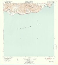
1952 Map of Punta Tuna
USGS Topo · Published 1953About this map
Hacienda San Isidro and the coastal settlements of Maunabo appear during a period of transition in the early 1950s, as documented by Roberto Sanchez Vilella and the Department of Public Works. The landscape is defined by the sharp rise of the Sierra de Guardarraya and Cerro Piedra Hueca from the Caribbean Sea, creating a narrow inhabited corridor along the southern shore. The map details the local infrastructure of the era, including the Escuela Segunda Unidad de Guardarraya and the residential clusters at Barriada Lanboglia. To the east, the maritime importance of the area is anchored by the Faro lighthouse at Pta Tuna near Puerto Maunabo. The coastal topography is intricately carved by numerous streams, such as the Quebrada de la Florida and Quebrada de las Mieles, which flow from the interior highlands toward the prominent headlands at Cabo Mala Pascua and Pta Viento.
Find a feature on this map
28 named features on this map. Tap any name to fly to it.
Don’t see what you’re looking for? This feature index may not catch every label — zoom into the map to look around manually.
Map Details
Editions of this 1952 Punta Tuna Map
2 editions found
Other maps of this area

1945 · Punta Tuna
USGS Topo · 1:30,000

1946 · Patillas
USGS Topo · 1:30,000

1946 · Punta Guayanes
USGS Topo · 1:30,000

1946 · Yabucoa
USGS Topo · 1:30,000

1946 · Guayama
USGS Topo · 1:30,000

1947 · Yabucoa SO
USGS Topo · 1:10,000
1947 · Guayama NE
USGS Topo · 1:10,000
1947 · Punta Tuna NO
USGS Topo · 1:10,000
1947 · Yabucoa SE
USGS Topo · 1:10,000
1947 · Patillas SE
USGS Topo · 1:10,000
Featured Places
- Sector Higuero, Patillas
- Sector Bordaleza, Maunabo
- Sector María Marisca, Patillas
- Barro Blanco, Patillas
- Ríos, Patillas