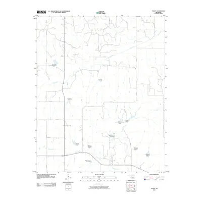
2009 Map of Purdy
USGS Topo · Published 2009About this map
Purdy Cemetery stands near the intersection of several local routes, serving as a primary genealogical landmark in this rural Garvin County landscape. The area is defined by a sophisticated water management network, evidenced by numerous structures such as the Rush Creek Site 28 Dam and the Wildhorse Creek Site 93 Dam. These dams are part of a broader conservation effort along the drainage basins of Rush Creek, Salt Creek, and Wildcat Creek. The settlement pattern follows a grid of section-line roads, including Wallville Rd and Goad Rd, which connect remote farmsteads. Near the center of the quadrangle, Camp Keno Taunee provides a rare recreational or communal landmark amidst the agricultural fields and riparian corridors. This 2009 survey illustrates the late-twentieth-century shift toward integrated flood control and watershed management in Oklahoma's prairie-timber transition zone.
Find a feature on this map
37 named features on this map. Tap any name to fly to it.
Don’t see what you’re looking for? This feature index may not catch every label — zoom into the map to look around manually.
Map Details
Editions of this 2009 Purdy Map
This is the sole edition of this map. No revisions or reprints were ever made.
Other maps of this area

1898 · Pauls Valley
USGS Topo · 1:125,000

1902 · Pauls Valley
USGS Topo · 1:125,000

1902 · Rush Springs
USGS Topo · 1:125,000

1957 · Ardmore
USGS Topo · 1:250,000

1963 · Ardmore
USGS Topo · 1:250,000

1965 · Maysville
USGS Topo · 1:24,000

1966 · Lindsay
USGS Topo · 1:24,000

1966 · Lindsay SW
USGS Topo · 1:24,000
1969 · Elmore City North
USGS Topo · 1:24,000
1969 · Elmore City South
USGS Topo · 1:24,000