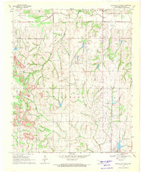
1969 Map of Elmore City North
USGS Topo · Published 1971About this map
Lindsay Oil Field dominates the northern landscape of this Oklahoma quadrangle, where a dense network of wells and service roads overlays the natural drainage of Rush Creek. The map records a critical period of mid-century petroleum infrastructure, featuring a central Refinery and a nearby Substation north of the growing settlement of Elmore City. This industrial presence contrasts with the older rural landmarks of the region, such as the small community of Antioch and the Antioch Cem. Moving south and west, the terrain becomes more varied as it rises toward Table Hill. The hydrological landscape is defined by the winding paths of Honey Creek and the bifurcated branches of West Rock Creek and East Landing Strip Rock Creek, illustrating the transition from the heavy industrial activity of the oil fields to the more open ranching and agricultural lands at the edge of the Whitebead area.
Find a feature on this map
20 named features on this map. Tap any name to fly to it.
Don’t see what you’re looking for? This feature index may not catch every label — zoom into the map to look around manually.
Map Details
Editions of this 1969 Elmore City North Map
2 editions found
Other maps of this area

1898 · Pauls Valley
USGS Topo · 1:125,000

1902 · Pauls Valley
USGS Topo · 1:125,000

1902 · Rush Springs
USGS Topo · 1:125,000

1957 · Ardmore
USGS Topo · 1:250,000

1963 · Ardmore
USGS Topo · 1:250,000

1965 · Maysville
USGS Topo · 1:24,000

1965 · Paoli
USGS Topo · 1:24,000

1966 · Lindsay
USGS Topo · 1:24,000

1969 · Hennepin
USGS Topo · 1:24,000
1969 · Elmore City NE
USGS Topo · 1:24,000