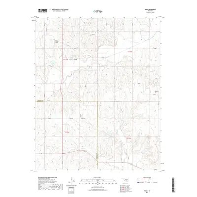
2018 Map of Purdy
USGS Topo · Published 2018About this map
The small settlement of Purdy sits at the intersection of a rural road network in south-central Oklahoma, serving as a focal point for the surrounding agricultural and ranching landscape. This 2018 survey reveals a community anchored by history, where the Purdy Cem and local landmarks like the Bearden Private Airstrip provide a record of long-term habitation. The terrain is defined by the drainage patterns of Rush Cr, Wildcat Cr, and Salt Cr, which carve through the land south of the prominent Table Hill.
Find a feature on this map
43 named features on this map. Tap any name to fly to it.
Don’t see what you’re looking for? This feature index may not catch every label — zoom into the map to look around manually.
Map Details
Editions of this 2018 Purdy Map
This is the sole edition of this map. No revisions or reprints were ever made.
Other maps of this area

1898 · Pauls Valley
USGS Topo · 1:125,000

1902 · Pauls Valley
USGS Topo · 1:125,000

1902 · Rush Springs
USGS Topo · 1:125,000

1957 · Ardmore
USGS Topo · 1:250,000

1963 · Ardmore
USGS Topo · 1:250,000

1965 · Maysville
USGS Topo · 1:24,000

1966 · Lindsay
USGS Topo · 1:24,000

1966 · Lindsay SW
USGS Topo · 1:24,000
1969 · Elmore City North
USGS Topo · 1:24,000
1969 · Elmore City South
USGS Topo · 1:24,000