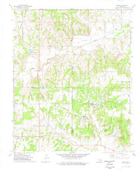
1974 Map of Purdy
USGS Topo · Published 1977About this map
The Lindsay Oil Field dominates the northern reaches of this landscape, where numerous oil wells and pipelines are interspersed among the drainages of Rush Creek. The map centers on the boundary between Garvin and Stephens counties, illustrating a rural community structure rooted in small settlements like Purdy and Doyle. Genealogists and local historians will find significant landmarks preserved here, including the Purdy Cem, the Doyle Sch, and Doyle Ch. To the south, the terrain shifts toward more wooded areas near Wildcat Creek and Salt Creek, where the Mountain View Ch and Camp Keno Taunee are located. The prominent elevation of Table Hill rises along the eastern edge, overlooking the network of rural section-line roads and scattered agricultural improvements that characterized this Oklahoma region in the mid-1970s.
Find a feature on this map
23 named features on this map. Tap any name to fly to it.
Don’t see what you’re looking for? This feature index may not catch every label — zoom into the map to look around manually.
Map Details
Editions of this 1974 Purdy Map
This is the sole edition of this map. No revisions or reprints were ever made.
Other maps of this area

1898 · Pauls Valley
USGS Topo · 1:125,000

1902 · Pauls Valley
USGS Topo · 1:125,000

1902 · Rush Springs
USGS Topo · 1:125,000

1957 · Ardmore
USGS Topo · 1:250,000

1963 · Ardmore
USGS Topo · 1:250,000

1965 · Maysville
USGS Topo · 1:24,000

1966 · Lindsay
USGS Topo · 1:24,000

1966 · Lindsay SW
USGS Topo · 1:24,000
1969 · Elmore City North
USGS Topo · 1:24,000
1969 · Elmore City South
USGS Topo · 1:24,000