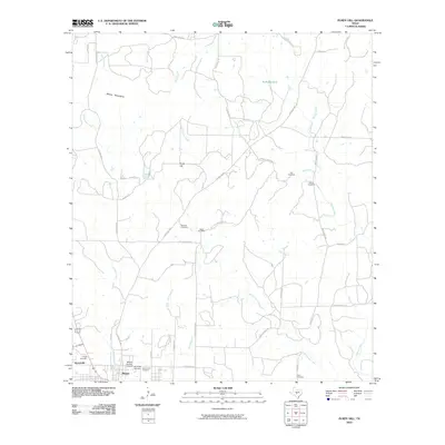
2010 Map of Purdy Hill
USGS Topo · Published 2010About this map
The Mason Historic District serves as the focal point of this Central Texas landscape, marking the seat of Mason County where historic architecture and local government converge. The map details the transition from the structured blocks of Mason and the nearby settlement of Koockville to the sprawling ranch lands and natural features that define the region. Family legacy is clearly etched into the terrain through a high density of rural burial grounds, including the Old Gooch Cemetery, New Gooch Cemetery, and Vater Cemetery.
Find a feature on this map
45 named features on this map. Tap any name to fly to it.
Don’t see what you’re looking for? This feature index may not catch every label — zoom into the map to look around manually.
Map Details
Editions of this 2010 Purdy Hill Map
This is the sole edition of this map. No revisions or reprints were ever made.
Other maps of this area

1887 · Mason
USGS Topo · 1:125,000

1894 · Mason
USGS Topo · 1:125,000

1954 · Llano
USGS Topo · 1:250,000

1955 · Llano
USGS Topo · 1:250,000

1956 · Llano
USGS Topo · 1:250,000

1962 · Purdy Hill
USGS Topo · 1:24,000
1962 · Fly Gap
USGS Topo · 1:24,000
1962 · Fredonia
USGS Topo · 1:24,000

1963 · Spy Rock
USGS Topo · 1:24,000
1967 · Art
USGS Topo · 1:24,000