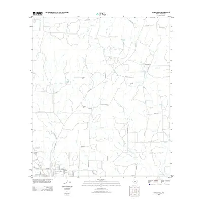
2012 Map of Purdy Hill
USGS Topo · Published 2012About this map
The Mason Historic District anchors the southwest corner of this landscape, where the confluence of several waterways shaped the early development of this Hill Country locale. Fed by the waters of Gamel Spring and the W Comanche Cr, the area shows a dense concentration of local history markers, including the Old Gooch Cem and New Gooch Cem. The surrounding terrain is defined by a network of drainage systems like Little Willow Cr and Mitchell Cr, which flow toward broader valleys past prominent landmarks such as Purdy Hill.
Find a feature on this map
64 named features on this map. Tap any name to fly to it.
Don’t see what you’re looking for? This feature index may not catch every label — zoom into the map to look around manually.
Map Details
Editions of this 2012 Purdy Hill Map
This is the sole edition of this map. No revisions or reprints were ever made.
Other maps of this area

1887 · Mason
USGS Topo · 1:125,000

1894 · Mason
USGS Topo · 1:125,000

1954 · Llano
USGS Topo · 1:250,000

1955 · Llano
USGS Topo · 1:250,000

1956 · Llano
USGS Topo · 1:250,000

1962 · Purdy Hill
USGS Topo · 1:24,000
1962 · Fly Gap
USGS Topo · 1:24,000
1962 · Fredonia
USGS Topo · 1:24,000

1963 · Spy Rock
USGS Topo · 1:24,000
1967 · Art
USGS Topo · 1:24,000