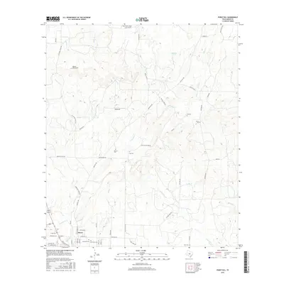
2016 Map of Purdy Hill
USGS Topo · Published 2016About this map
The town of Mason anchors the southwestern corner of this Hill Country landscape, where the street grid gives way to a sprawling network of ranch roads and rugged drainages. The topography is dominated by the Mason Mountains and Purdy Hill, with the terrain dissected by numerous watercourses including Katemcy Cr, Little Willow Cr, and Comanche Cr. This 2016 survey is particularly valuable for genealogical research, as it identifies several small family or community burial sites scattered across the ranchlands, such as Behrens Cem, Jones Cem, Polk Cem, and Ellison Cem. The map also documents the modern ranching infrastructure of the region, notably the Polk Ranch Airport and the complex system of secondary routes like Ranch Rd 386 and Old Pontotoc Rd that connect isolated homesteads to the county seat.
Find a feature on this map
59 named features on this map. Tap any name to fly to it.
Don’t see what you’re looking for? This feature index may not catch every label — zoom into the map to look around manually.
Map Details
Editions of this 2016 Purdy Hill Map
This is the sole edition of this map. No revisions or reprints were ever made.
Other maps of this area

1887 · Mason
USGS Topo · 1:125,000

1894 · Mason
USGS Topo · 1:125,000

1954 · Llano
USGS Topo · 1:250,000

1955 · Llano
USGS Topo · 1:250,000

1956 · Llano
USGS Topo · 1:250,000

1962 · Purdy Hill
USGS Topo · 1:24,000
1962 · Fly Gap
USGS Topo · 1:24,000
1962 · Fredonia
USGS Topo · 1:24,000

1963 · Spy Rock
USGS Topo · 1:24,000
1967 · Art
USGS Topo · 1:24,000