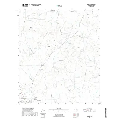
2019 Map of Purdy Hill
USGS Topo · Published 2019About this map
The Mason Mountains dominate the northwest corner of this quadrangle, giving way to a landscape defined by seasonal creek beds and scattered family landmarks. The town of Mason sits in the southwest, serving as a hub for the surrounding ranching country. Local history is deeply etched into the land through numerous small burial grounds, including the Old Gooch Cem and New Gooch Cem, alongside the Behrens Cem and Jones Cem. Aviation is represented by private facilities like the Polk Ranch Airport and Bar Triangle Airport. The hydrological network, centered on the drainage of Little Willow Cr, Mitchell Cr, and the springs at Gamel Spring, illustrates the vital importance of water management in this part of the Texas Hill Country.
Find a feature on this map
69 named features on this map. Tap any name to fly to it.
Don’t see what you’re looking for? This feature index may not catch every label — zoom into the map to look around manually.
Map Details
Editions of this 2019 Purdy Hill Map
This is the sole edition of this map. No revisions or reprints were ever made.
Other maps of this area

1887 · Mason
USGS Topo · 1:125,000

1894 · Mason
USGS Topo · 1:125,000

1954 · Llano
USGS Topo · 1:250,000

1955 · Llano
USGS Topo · 1:250,000

1956 · Llano
USGS Topo · 1:250,000

1962 · Purdy Hill
USGS Topo · 1:24,000
1962 · Fly Gap
USGS Topo · 1:24,000
1962 · Fredonia
USGS Topo · 1:24,000

1963 · Spy Rock
USGS Topo · 1:24,000
1967 · Art
USGS Topo · 1:24,000