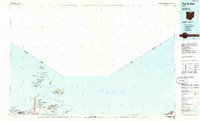
1986 Map of Put-In-Bay
USGS Topo · Published 1986About this map
Lake Erie and its western basin islands define this 1986 planimetric study, which focuses on the complex shoreline and navigation routes of the South Passage. The map highlights the seasonal and maritime character of the region, from the iconic Marblehead Lighthouse to the clustered archipelago containing North Bass Island, Middle Bass Island, and South Bass Island. The Ferry routes indicated across the water underscore the essential connections between the mainland at Catawba Island and the offshore communities.
Find a feature on this map
53 named features on this map. Tap any name to fly to it.
Don’t see what you’re looking for? This feature index may not catch every label — zoom into the map to look around manually.
Map Details
Editions of this 1986 Put-In-Bay Map
2 editions found
Other maps of this area

1900 · Oak Harbor
USGS Topo · 1:62,500

1901 · Oberlin
USGS Topo · 1:62,500

1901 · Put-In-Bay
USGS Topo · 1:62,500

1901 · Bellevue
USGS Topo · 1:62,500

1901 · Fremont
USGS Topo · 1:62,500

1902 · Berea
USGS Topo · 1:62,500

1903 · Bellevue
USGS Topo · 1:62,500

1903 · Vermilion
USGS Topo · 1:62,500

1903 · Fremont
USGS Topo · 1:62,500

1903 · Put In Bay
USGS Topo · 1:62,500