
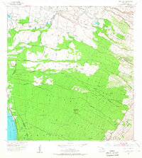
1954 Map of Puu O Kali
USGS Topo · Published 1956About this map
Puu o Kali rises above a landscape of mid-century homesteading and agricultural development on the leeward slopes of Maui. This 1954 field-checked survey reveals an intricate network of residential allotments, including the Waiohuli Keokea Beach Homesteads and Waiakoa Homesteads, illustrating the mid-century transition of former ranch and plantation lands into organized residential districts. The northern reaches show the industrial influence of the sugar era with the presence of Camp K-3 and the Pulehu Camp (site) near the Maui Airport (Puunene Airport). Water management is central to the terrain, marked by numerous water tanks and reservoirs needed to support life on the dry, gulch-cut slopes of Alae and Keokea. Local history is anchored at the Puu Hale Cemetery and Lihue Cem, while the Haleakala Highway provides the primary artery through the diverse districts of Kealahou and Omaopio Homesteads.
Find a feature on this map
49 named features on this map. Tap any name to fly to it.
Don’t see what you’re looking for? This feature index may not catch every label — zoom into the map to look around manually.
Map Details
Editions of this 1954 Puu O Kali Map
2 editions found
Other maps of this area

1954 · Maui
USGS Topo · 1:250,000

1954 · Maalaea
USGS Topo · 1:24,000

1954 · Paia
USGS Topo · 1:24,000

1954 · Makena
USGS Topo · 1:24,000

1955 · Wailuku
USGS Topo · 1:24,000

1957 · Kilohana
USGS Topo · 1:24,000

1957 · Haiku
USGS Topo · 1:24,000

1957 · Lualailua Hills
USGS Topo · 1:24,000

1966 · Maui
USGS Topo · 1:250,000

1974 · Maui
USGS Topo · 1:250,000