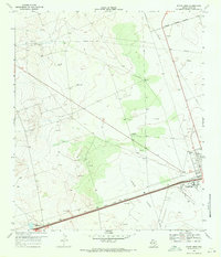
1969 Map of Pyote West
USGS Topo · Published 1971About this map
Pyote Flats and the surrounding Chihuahuan Desert landscape dominate this survey of Ward County during the late 1960s. The map illustrates a region defined by its industrial and social infrastructure, notably the West Texas Childrens Home located just south of the town of Pyote. The heavy influence of the Permian Basin's energy sector is evident in the dense network of pipelines and numerous scattered Oil Wells, including specifically named sites like Oats Well, Hookedy Well, and Texas Well. Transportation is anchored by the Texas and Pacific railroad, which runs parallel to the highway corridor in the southern portion of the sheet. Outside the main settlement, the landscape remains sparsely developed, featuring family-named landmarks like Wilson Ranch and isolated water sources such as Rogers Windmill and The Lake, which together provide a clear picture of the rural ranching and resource extraction economy of the era.
Find a feature on this map
23 named features on this map. Tap any name to fly to it.
Don’t see what you’re looking for? This feature index may not catch every label — zoom into the map to look around manually.
Map Details
Editions of this 1969 Pyote West Map
2 editions found
Other maps of this area

1931 · Barstow
USGS Topo · 1:125,000

1954 · Pecos
USGS Topo · 1:250,000

1957 · Pecos
USGS Topo · 1:250,000

1963 · Quito Draw
USGS Topo · 1:24,000

1963 · China Lake NE
USGS Topo · 1:24,000

1963 · China Lake
USGS Topo · 1:24,000

1968 · Soda Lake SE
USGS Topo · 1:24,000

1968 · Wink South
USGS Topo · 1:24,000

1968 · Soda Lake NE
USGS Topo · 1:24,000

1969 · Pyote NE
USGS Topo · 1:24,000