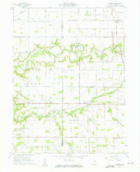
1961 Map of Pyrmont
USGS Topo · Published 1962About this map
The winding course of Wildcat Creek and its Middle Fork carve through the agricultural heart of Tippecanoe and Carroll counties in this early 1960s survey. The landscape is defined by the sharp transition between flat, gridded uplands and the wooded, deeply incised stream valleys where rural hamlets like Pyrmont and Owasco are situated. This era shows the local transportation network in detail, from the Monon railroad corridor near Ockley to family-named routes like Schimmel Road and Stull Road. Religious and social hubs are clearly marked, including Bethel Ch and Oxford Ch, alongside several quiet burial grounds such as St Johns Cem. The presence of the Sycamore Valley Camp and a distinct landform known as The Mound provides insight into the recreational and geological character of the region during the mid-century.
Find a feature on this map
53 named features on this map. Tap any name to fly to it.
Don’t see what you’re looking for? This feature index may not catch every label — zoom into the map to look around manually.
Map Details
Editions of this 1961 Pyrmont Map
2 editions found
Other maps of this area

1953 · Danville
USGS Topo · 1:250,000

1955 · Danville
USGS Topo · 1:250,000

1956 · Danville
USGS Topo · 1:250,000

1961 · Mulberry
USGS Topo · 1:24,000

1961 · Pyrmont
USGS Topo · 1:24,000

1961 · Stockwell
USGS Topo · 1:24,000

1961 · Lafayette East
USGS Topo · 1:24,000

1961 · Rossville
USGS Topo · 1:24,000

1961 · Frankfort
USGS Topo · 1:24,000

1962 · Flora
USGS Topo · 1:24,000