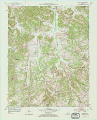
1953 Map of Quality
USGS Topo · Published 1967About this map
Muddy Creek and its many tributaries, including Dallam Creek and Duncan Creek, define the drainage patterns of this rural landscape along the Butler and Logan County line. The early 1950s environment is characterized by a high density of small rural schools and churches, suggesting a community structure still centered around local districts. Notable educational sites such as Union Grove Sch, Toy Spring Sch, and Caney Fork Sch are scattered throughout the hills, while religious life is anchored by Mt Zion Ch and Sand Spring Ch. Small settlements like Quality and Biggerstaff serve as local hubs, with Turnertown notably housing the Berrys Lick Post Office. An industrial element is introduced near Forgus, where several Oil Wells are located, while crossing points like Lees Bridge indicate the essential transportation infrastructure of the era.
Find a feature on this map
32 named features on this map. Tap any name to fly to it.
Don’t see what you’re looking for? This feature index may not catch every label — zoom into the map to look around manually.
Map Details
Editions of this 1953 Quality Map
2 editions found
Other maps of this area

1911 · Dunmor
USGS Topo · 1:48,000

1914 · Little Muddy
USGS Topo · 1:62,500

1914 · Dunmor
USGS Topo · 1:62,500

1951 · Lewisburg
USGS Topo · 1:24,000

1951 · South Union
USGS Topo · 1:24,000

1951 · Homer
USGS Topo · 1:24,000

1953 · Dunmor
USGS Topo · 1:24,000

1953 · South Hill
USGS Topo · 1:24,000

1953 · Quality
USGS Topo · 1:24,000

1953 · Rochester
USGS Topo · 1:24,000