
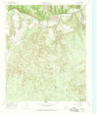
1927 Map of Quanah 3-b
USGS Topo · Published 1927About this map
The Pease River meanders through a landscape of intricate topographic relief in this 1927 survey, which captures the meeting point of three North Texas counties. This advance sheet, compiled in part from aerial photographs taken by the Air Corps, provides a detailed look at the drainage patterns and terrain before significant modern development altered the region. The map meticulously documents the political boundaries where Cottle and Hardeman counties meet, and where both join Foard County to the south. This transition zone is characterized by the complex erosion patterns along the river valley, offering a precise record of the natural geography and land divisions during the late 1920s.
Find a feature on this map
4 named features on this map. Tap any name to fly to it.
Don’t see what you’re looking for? This feature index may not catch every label — zoom into the map to look around manually.
Map Details
Editions of this 1927 Quanah 3-b Map
This is the sole edition of this map. No revisions or reprints were ever made.
Other maps of this area

1927 · Quanah 3-a
USGS Topo · 1:48,000

1932 · Vivian
USGS Topo · 1:62,500

1954 · Plainview
USGS Topo · 1:250,000

1955 · Lawton
USGS Topo · 1:250,000

1958 · Plainview
USGS Topo · 1:250,000

1960 · Goodlett
USGS Topo · 1:62,500

1960 · Teacup Mountain
USGS Topo · 1:62,500

1967 · Kirkland South
USGS Topo · 1:24,000

1967 · Triangle Ranch
USGS Topo · 1:24,000
1967 · Baker
USGS Topo · 1:24,000