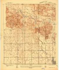
1937 Map of Quanah Mountain
USGS Topo · Published 1937About this map
The Wichita Mountains Wildlife Refuge dominates the northern half of this landscape, showcasing the area's development during the New Deal era. Two Civilian Conservation Corps sites, C C C Camp No 870 and C C C Camp No 859, are visible, alongside infrastructure like the Refuge Headquarters. The presence of these camps suggests active conservation and construction work on features such as Quanah Parker Lake and Lake Burford. To the south, the terrain levels out near the settlement of Cache, which is served by the St Louis San Francisco railroad line.
Find a feature on this map
45 named features on this map. Tap any name to fly to it.
Don’t see what you’re looking for? This feature index may not catch every label — zoom into the map to look around manually.
Map Details
Editions of this 1937 Quanah Mountain Map
This is the sole edition of this map. No revisions or reprints were ever made.
Other maps of this area
1937 · Cache
USGS Topo · 1:48,000
1942 · Cache
USGS Topo · 1:62,500
1949 · Mount Scott
USGS Topo · 1:24,000
1949 · Cooperton
USGS Topo · 1:62,500
1949 · Quanah Mountain
USGS Topo · 1:24,000
1950 · Snyder
USGS Topo · 1:62,500
1950 · Saddle Mountain
USGS Topo · 1:62,500

1955 · Lawton
USGS Topo · 1:250,000
1956 · Post Oak Creek
USGS Topo · 1:24,000
1956 · Saddle Mountain
USGS Topo · 1:24,000