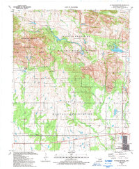
1991 Map of Quanah Mountain
USGS Topo · Published 1992About this map
The Wichita Mountains National Wildlife Refuge dominates the northern half of this landscape, showcasing a complex network of recreation and conservation land established long before this late-century survey. The terrain transitions from the jagged peaks of the Charons Garden Mountains and Elk Mountain down to the established settlement of Cache in the southeast. Evidence of the region’s early industrial interests remains at the Bonanza Mine and Pennington Mine, while the southern portion of the sheet is defined by the rigid boundaries of the Fort Sill Military Reservation. Numerous reservoirs, including Quanah Parker Lake and French Lake, indicate the careful management of water resources within the Wichita Mountains. Distinctive landmarks like the Boulder Field and The Narrows highlight the unique geological formations that have made this area a focal point for Oklahoma outdoorsmen and conservationists for decades.
Find a feature on this map
68 named features on this map. Tap any name to fly to it.
Don’t see what you’re looking for? This feature index may not catch every label — zoom into the map to look around manually.
Map Details
Editions of this 1991 Quanah Mountain Map
2 editions found
Other maps of this area

1937 · Cache
USGS Topo · 1:48,000

1937 · Quanah Mountain
USGS Topo · 1:24,000

1942 · Cache
USGS Topo · 1:62,500

1949 · Mount Scott
USGS Topo · 1:24,000

1949 · Cooperton
USGS Topo · 1:62,500

1949 · Quanah Mountain
USGS Topo · 1:24,000

1950 · Snyder
USGS Topo · 1:62,500

1950 · Saddle Mountain
USGS Topo · 1:62,500

1955 · Lawton
USGS Topo · 1:250,000

1956 · Post Oak Creek
USGS Topo · 1:24,000