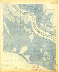
1892 Map of Quarantine
USGS Topo · Published 1905About this map
Linear riverfront settlements define this late nineteenth-century landscape along the lower reaches of the Mississippi River. Unlike traditional town grids, habitation here follows the narrow natural levees between the river and the encroaching marshlands. The dense concentration of homes and small landings is captured in labels for the Grand Settlement and Buras Settlement, while individual landing points such as Home Place and Daisy suggest the river-dependent economy of the era.
Find a feature on this map
56 named features on this map. Tap any name to fly to it.
Don’t see what you’re looking for? This feature index may not catch every label — zoom into the map to look around manually.
Map Details
Editions of this 1892 Quarantine Map
5 editions found
Other maps of this area

1891 · Pointe a La Hache
USGS Topo · 1:62,500

1892 · Quarantine
USGS Topo · 1:62,500

1892 · Pointe a La Hache
USGS Topo · 1:62,500

1893 · La Fortuna
USGS Topo · 1:62,500

1893 · Forts
USGS Topo · 1:62,500

1893 · Fort Livingston
USGS Topo · 1:62,500

1893 · Dime
USGS Topo · 1:62,500

1893 · West Delta
USGS Topo · 1:62,500

1935 · Port Sulphur
USGS Topo · 1:31,680

1935 · Bastian Bay
USGS Topo · 1:31,680