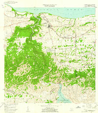
1957 Map of Quebradillas
USGS Topo · Published 1961About this map
The town of Quebradillas sits on the northwestern coast of Puerto Rico, perched above the Atlantic Ocean and the deep, winding valley of the Rio Guajataca. In the late 1950s, this landscape was defined by its agricultural character and rural barrio settlements such as San Antonio, Charcas, and Piedra Gorda. The Ferrocarril rail line follows the coastline, passing through Guayabos and Terranova, while the interior is marked by numerous rural schools like Escuela Segunda Unidad Rivera and Escuela Salvador Brau. In the southern reaches, the Lago de Guajataca reservoir serves as a major geographical anchor, with the Iglesia San Antonio de Padua located nearby. The map illustrates a transition from the coastal plains to the limestone hills, showing landmarks such as La Casa de Piedra and the small community of Pueblito de Ponce.
Find a feature on this map
57 named features on this map. Tap any name to fly to it.
Don’t see what you’re looking for? This feature index may not catch every label — zoom into the map to look around manually.
Map Details
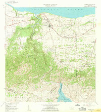
Editions of this 1957 Quebradillas Map
2 editions found
Other maps of this area

1937 · Moca
USGS Topo · 1:20,000

1938 · Alto Sano
USGS Topo · 1:20,000

1938 · Camuy
USGS Topo · 1:20,000

1938 · San Sebastian
USGS Topo · 1:20,000

1938 · Quebradillas
USGS Topo · 1:20,000

1941 · Moca
USGS Topo · 1:30,000

1941 · Isabela
USGS Topo · 1:30,000

1941 · San Sebastian
USGS Topo · 1:30,000

1942 · Moca
USGS Topo · 1:30,000

1942 · Central La Plata
USGS Topo · 1:30,000
Featured Places
- Quebradillas
- Reparto Apolonio Vélez Ramos, Isabela
- Villa Ledumerced, Quebradillas
- Hacienda La Sabana, Camuy
- Brisas de la Sabana, Camuy