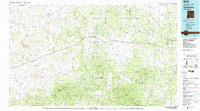
1983 Map of Quemado
USGS Topo · Published 1983About this map
Quemado and the iconic settlement of Pie Town anchor this high-desert landscape in the early 1980s, where the winding Continental Divide separates the drainage of the Apache National Forest and Cibola National Forest. The map illustrates a transition from the rugged Mangas Mountains to the expansive plateaus of Tejana Mesa and Largo Mesa. This region is defined by its complex network of seasonal drainages, such as Largo Creek and Sawmill Draw, which carve through the volcanic and sedimentary terrain. Notable landmarks including Adams Diggings and the isolated peaks of Cerro Prieto and Castle Rock provide specific points of interest for those studying the land use and geologic character of western Catron County. The alignment of U.S. 60 serves as the primary artery connecting these remote ranching and forest communities.
Find a feature on this map
63 named features on this map. Tap any name to fly to it.
Don’t see what you’re looking for? This feature index may not catch every label — zoom into the map to look around manually.
Map Details
Editions of this 1983 Quemado Map
2 editions found
Other maps of this area

1886 · St Johns
USGS Topo · 1:250,000

1892 · St Johns
USGS Topo · 1:250,000

1915 · Reserve
USGS Topo · 1:125,000

1917 · Broom Mountain
USGS Topo · 1:125,000

1918 · Pelona
USGS Topo · 1:125,000

1918 · Reserve
USGS Topo · 1:125,000

1922 · Nutrioso
USGS Topo · 1:125,000

1954 · Tularosa
USGS Topo · 1:250,000

1954 · Clifton
USGS Topo · 1:250,000

1954 · Saint Johns
USGS Topo · 1:250,000