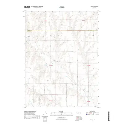
2017 Map of Quick SE
USGS Topo · Published 2017About this map
The boundary between Frontier Co Red Willow Co cuts across this section of southwestern Nebraska, where agricultural land management is defined by an extensive network of waterways. Water management is central to the landscape, with the Red Willow Cr joined by man-made infrastructure including the Red Willow Canal and the Culbertson Extension Canal. These features, along with the Larington Reservoir, indicate the transition of the high plains into a productive irrigation-based economy. For those tracing local history, the Box Elder Cem sits centrally among the section lines and rural routes such as RD 723. The terrain is marked by significant natural drainages like Bee Canyon and River Canyon, which interrupt the regular grid of the township and range system.
Find a feature on this map
28 named features on this map. Tap any name to fly to it.
Don’t see what you’re looking for? This feature index may not catch every label — zoom into the map to look around manually.
Map Details
Editions of this 2017 Quick SE Map
This is the sole edition of this map. No revisions or reprints were ever made.
Other maps of this area

1954 · McCook
USGS Topo · 1:250,000

1956 · Quick NE
USGS Topo · 1:24,000

1956 · Bartley NW
USGS Topo · 1:24,000

1957 · McCook
USGS Topo · 1:250,000

1958 · McCook
USGS Topo · 1:250,000
1958 · Indianola
USGS Topo · 1:24,000

1970 · Red Willow Dam
USGS Topo · 1:24,000

1970 · Quick
USGS Topo · 1:24,000

1970 · McCook West
USGS Topo · 1:24,000

1970 · Quick SE
USGS Topo · 1:24,000