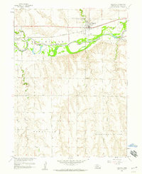
1958 Map of Indianola
USGS Topo · Published 1959About this map
Indianola serves as the focal point of this Red Willow County landscape during the late 1950s, situated at the confluence of river-driven infrastructure and agricultural progress. The Republican River valley is heavily modified here, featuring an extensive levee system and the Bartley Canal which diverts water through a series of siphons to support local farming. The Chicago Burlington and Quincy railroad tracks parallel the river, connecting the elevators and processing areas of the town to broader markets.
Find a feature on this map
23 named features on this map. Tap any name to fly to it.
Don’t see what you’re looking for? This feature index may not catch every label — zoom into the map to look around manually.
Map Details
Editions of this 1958 Indianola Map
2 editions found
Other maps of this area

1954 · McCook
USGS Topo · 1:250,000

1956 · Bartley
USGS Topo · 1:24,000

1957 · McCook
USGS Topo · 1:250,000

1957 · Danbury
USGS Topo · 1:24,000

1957 · Lebanon
USGS Topo · 1:24,000

1957 · McCook SE
USGS Topo · 1:24,000

1957 · Danbury NE
USGS Topo · 1:24,000

1958 · McCook
USGS Topo · 1:250,000

1958 · Danbury NE
USGS Topo · 1:24,000

1970 · Quick SE
USGS Topo · 1:24,000