
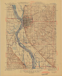
1945 Map of Quincy
USGS Topo · Published 1945About this map
Quincy dominates the bluffs overlooking the Mississippi River, serving as a major rail hub for the Chicago Burlington and Quincy RR as it enters Illinois. The map captures a detailed landscape of public institutions and rural communities at the end of the war, including the Soldiers Home and a dense network of country schools such as St Ludgerus School and Franklin School.
Find a feature on this map
106 named features on this map. Tap any name to fly to it.
Don’t see what you’re looking for? This feature index may not catch every label — zoom into the map to look around manually.
Map Details
Editions of this 1945 Quincy Map
2 editions found
Other maps of this area

1903 · Kahoka
USGS Topo · 1:125,000

1903 · Palmyra
USGS Topo · 1:125,000

1925 · Quincy
USGS Topo · 1:62,500

1925 · Liberty
USGS Topo · 1:62,500

1927 · Liberty
USGS Topo · 1:62,500

1931 · Barry
USGS Topo · 1:62,500

1932 · Hannibal
USGS Topo · 1:62,500

1936 · Hannibal
USGS Topo · 1:48,000

1936 · Barry
USGS Topo · 1:48,000

1944 · Barry
USGS Topo · 1:62,500