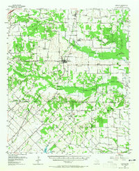
1956 Map of Quinlan
USGS Topo · Published 1965About this map
The Texas and New Orleans (Southern Pacific) railroad cuts a diagonal path through the landscape, connecting rural communities across Hunt, Kaufman, and Van Zandt counties. This mid-century survey reveals a patchwork of small settlements and family-named landmarks like Graham Point and Ables Springs. The Quinlan townsite serves as a central hub, surrounded by smaller agrarian clusters such as Stringtown and Poetry.
Find a feature on this map
62 named features on this map. Tap any name to fly to it.
Don’t see what you’re looking for? This feature index may not catch every label — zoom into the map to look around manually.
Map Details
Editions of this 1956 Quinlan Map
3 editions found
Other maps of this area

1919 · Royse City
USGS Topo · 1:62,500

1930 · Farmersville
USGS Topo · 1:62,500

1953 · Texarkana
USGS Topo · 1:250,000

1954 · Dallas
USGS Topo · 1:250,000

1954 · Sherman
USGS Topo · 1:250,000

1956 · Texarkana
USGS Topo · 1:250,000

1956 · Kaufman
USGS Topo · 1:62,500

1956 · Tyler
USGS Topo · 1:250,000

1956 · Quinlan
USGS Topo · 1:62,500

1956 · Emory
USGS Topo · 1:62,500