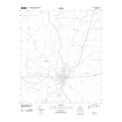
2011 Map of Quitman
USGS Topo · Published 2011About this map
Okapilco Creek and its many tributaries, including Possum Branch and Coon Creek, dominate the rural landscape of Brooks County. The city of Quitman serves as the central hub, surrounded by several smaller rural settlements such as Spain, Fodie, and Shiver. The distribution of burial grounds throughout the countryside, including Oak Hill Cemetery, North End Cemetery, and Bethlehem Cemetery, suggests a long-established network of family farms and early church communities. Transportation in the region is defined by a web of local routes like Troupeville Rd and Old Valdosta Rd, while the Quitman-Brooks County Airport northwest of the city center marks a modern infrastructure development in this traditionally agricultural area.
Find a feature on this map
42 named features on this map. Tap any name to fly to it.
Don’t see what you’re looking for? This feature index may not catch every label — zoom into the map to look around manually.
Map Details
Editions of this 2011 Quitman Map
This is the sole edition of this map. No revisions or reprints were ever made.
Other maps of this area

1954 · Valdosta
USGS Topo · 1:250,000

1956 · Grooverville
USGS Topo · 1:24,000

1956 · Nankin
USGS Topo · 1:24,000

1956 · Baden
USGS Topo · 1:24,000

1958 · Valdosta
USGS Topo · 1:250,000

1959 · Valdosta
USGS Topo · 1:250,000

1961 · Quitman
USGS Topo · 1:62,500

1961 · Hahira West
USGS Topo · 1:24,000

1961 · Ousley
USGS Topo · 1:24,000
1974 · Quitman
USGS Topo · 1:24,000